Summary
January 18, 2011: Introduction to geodesy. Geodesy is the science of measuring the Earth's shape, gravity field, and rotation. Geodesy is a very old science, and four main phases can be identified based on the view of the Earth's shape and dynamics and the main target of research. The current phase is characterized by a dynamic view of the Earth system and a transition from a Newtonian to a relativistic theory. Geodesy can be pictured by its three pillars Earth shape, Earth gravity field, and Earth rotation. these pillars are inherently linked and observations of these three pillars allow the determination of the reference frames required for geodesy. Modern geodetic techniques are impacted by many Earth system processes and this opens for a number of new applications of geodesy in all earth sciences.
1.1 Geodesy: The science of measuring the Earth's shape, gravity field, and rotation
(Note: The following text is mainly taken from Plag et al., 2009a).
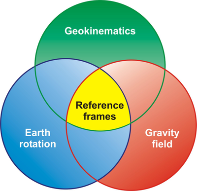
Geodesy is the discipline that deals with the measurement and representation (geometry, physics, temporal variations) of the Earth and other celestial bodies (Sideris, 2007). The “three pillars” of geodesy are the Earth's time-dependent geometric shape, gravitational field, and rotation (Figure 1). Today, along with these pillars a number of related quantities are observed with terrestrial and space-geodetic techniques using a combination of spaceborne and airborne sensors and in situ networks. With its observational means, geodesy has the potential to determine, unambiguously and with utmost precision, the geometric shape of land, ice, and ocean surfaces as a global function of space and time. Since the dense web of microwave radiation used for geodetic positioning passes through the atmosphere, its interaction with the atmosphere yields important weather parameter information. The geometric methods when combined with global gravity information and the geoid, allow us to infer mass anomalies, mass transport phenomena and mass exchange in the Earth's system. Finally, the variations in Earth rotation reflect mass transport in the Earth system and the exchange of angular momentum among its components.
Observations of the Earth's variable shape, gravity field, and rotation provide the basis for the realization of the reference systems that are required in order to assign (time-dependent) coordinates to points and objects, and to describe the motion of the Earth in space (Figure 1). For this purpose, two reference systems are intrinsic in geodesy, namely the celestial reference system and the terrestrial reference system, which are dynamically linked to each other by the Earth's rotation. The two most accurate reference systems currently available are the International Celestial Reference System (ICRS) and the International Terrestrial Reference System (ITRS) (see Lecture 2 for more details), which are defined by the International Earth Rotation and Reference Systems Service (IERS). These systems are conventional coordinate systems that include all conventions for the orientation and origin of the axes, the scale, and the physical constants, models, and processes to be used in their realization. Based on observations, these systems can be realized through their corresponding “reference frames”. The frame corresponding to the ICRS is the International Celestial Reference Frame (ICRF), which is a set of estimated positions of extragalactic reference radio sources. The frame corresponding to the ITRS is the International Terrestrial Reference Frame (ITRF), which is a set of estimated positions and velocities of globally distributed reference marks on the solid Earth's surface. These two frames are linked to each other by estimates of the Earth Orientation Parameters (EOPs). ICRS, ITRF and the EOP are provided by IERS.
Today, the internationally coordinated geodetic observations of the global geodetic station networks provide a continuous monitoring of the ITRF. This well-defined, long-term stable, highly-accurate, and easily accessible reference frame is the basis for all precise positioning on and near the Earth's surface. It is the indispensable foundation for all sustainable Earth observations, in situ, as well as airborne and spaceborne. Furthermore the ITRF underpins all geo-referenced data used by society for so many uses. At the most foundational level the ITRF rigorously supports the Spatial Data Infrastructure (SDI). The SDI is a model of all geo-referenced data that consists of many layers, all connected to the geodesy layer which is the realization of the ITRF at national and regional (and increasingly the international) scale. The other layers of the SDI are like elements of a “house”, built on strong foundations, and include map and image data of the physical surface of the Earth, its terrain, waterways, forests, vegetation and habitats; transport and built infrastructure such as roads, railways, and other structures; cadastral land boundaries; political boundaries; and many others. These layers of digital geo-referenced data are crucial for many activities, ranging from mapping, construction, land development, natural resource management and conservation, navigation - in fact all decision-making that has a geo-related component.
|
Figure 1.1: Constituents of an integrated geodetic monitoring system. The “three pillars” of geodesy provide the conceptual and observational basis for the reference frames required for Earth observation. These three pillars are intrinsically linked to each other as they provide different observation related to the same Earth system processes.
|
Historically, geodesy was limited to determining the shape of the Earth, its gravity field, and its rotation including their changes over time. With modern instrumentation and analytical techniques, the scope of geodesy has extended to include the causes of the observed changes, i.e., the dynamics of and mass transport within the Earth system. With this broader scope, new pathways emerge in which geodesy can contribute to the scientific understanding of the Earth system as well as the development, functioning, and security of society in general.
To a large extent, geodesy is a “service science”. In the past, the main “customers” of geodesy came from the surveying and mapping profession, while today geodesy serves all Earth science, including the geophysical, oceanographic, atmospheric, and environmental science communities. Consequently, today the development of the geodetic observing system is guided by the user requirements of a much broader “customer” base.
With the “three pillars”, geodesy precisely observes and consistently monitors mass movement in the Earth system and its associated dynamics:
- Geokinematics: measuring the geometric shape of the Earth's surface (solid Earth, ice and oceans) and its kinematics and variations, on global to local spatial scales, and at time scales from rapid to secular;
- Earth rotation: monitoring the variations of the Earth's rotation as an indicator of all angular momentum exchange inside, on or above the solid Earth, as well as of the torques acting on the solid Earth (including those due to the Sun and Moon); and
- Gravity field: determining and monitoring the Earth's gravity field and inferring the underlying mass redistributions in the solid Earth, liquid core, atmosphere, oceans, hydrosphere, and cryosphere.
Ultimately, all geodetic observations are affected by the same physical Earth system processes. Thus, geodesy provides a unique framework for monitoring and ultimately understanding the Earth system as a whole. Modern space-geodetic techniques are well suited for observing phenomena on global to regional scales, and thus are an important complement to traditional in situ observation systems.
The rapid development of space-geodetic techniques also enables auxiliary applications that utilize the atmospheric disturbance of geodetic measurements (ionosphere, troposphere, magnetic field) for non-geodetic applications. Atmospheric disturbances formerly were the natural factor limiting the accuracy of geodetic measurements. Now this “noise” is increasingly being recognized as “signal”, and the distortions of microwave signals propagating through the atmosphere can be “inverted” for atmospheric parameters and utilized for numerical weather prediction (e.g., Jerrett and Nash, 2001, Elgered et al., 2005), climate studies, and studies in atmospheric physics.
A major driver for the development of the geodetic observing system is the progress of science. In addition, technological advances with improved sensors, networks, and communications, the impact of nanotechnology, and the development of new and improved observing systems (for example, Interferometric Synthetic Aperture Radar, InSAR; LIght Detection And Ranging, LIDAR; and all remote sensing missions, including Gravity Recovery and Climate Experiment, GRACE; Gravity field and steady-state Ocean Circulation Explorer, GOCE; and future satellite missions) are key drivers. As pointed out above, the mounting pressure of environmental changes and the associated societal needs demand improved Earth observations which in turn put increasing demands on the geodetic observing system. Issue such as hazards monitoring and understanding of global change, the exponential growth of, and need for, geo-spatial information, and the complexity and scale of the global problems that cannot be solved by a single science require a well developed geodetic observing system. Geodetic expertise is therefore increasingly needed, and valued, by other sciences (Sideris, 2007).
With this development, geodesy faces several challenges (Sideris, 2007), namely: (1) inter-disciplinarity is required in order to contribute to collaborative solutions to problems, to allow for an optimal assimilation of a wide spectrum of observations into inter-disciplinary models, and to enable to interpretation and separability of the various signals; (2) development of a framework for a four-dimensional geodesy is required, in which temporal variations in the shape of the Earth and its gravity field are fully accounted for, long-term observation campaigns and archiving are planned with the 4-D nature of the system in mind, and an accuracy level for geometric and gravimetric quantities of much better than 10-9 (approaching 10-12) is achieved; and (3) the recognition of what geodesy is and who benefits from needs to be communicated through appropriate outreach, and geodesy faces the challenge of how best to promote the geodetic contributions to science and society at large.
Many scientific applications depend on a detailed knowledge of the Earth's shape, its gravity field and rotation, and in the past geodesy has (with ever-increasing accuracy) provided the necessary observations. The relatively recent advent of space-geodetic techniques has brought about a rapid development in global geodesy. The relative precision of the measurements is approaching the very impressive level of 1 ppb or even better. Today, geodetic techniques permit the measurement of changes in the geometry of the Earth's surface with an accuracy of millimeters over distances of several thousand km.
Over the last one and a half decades, the global geodetic networks have provided an increasingly detailed picture of the kinematics of points on the Earth's surface and the temporal variations in the Earth's shape. Among other applications, the observations have been used to determine improved models of the secular horizontal velocity field (e.g., Kreemer and Holt, 2001; Kierulf et al., 2003, Kreemer et al., 2003), to derive seasonal variations in the terrestrial hydrosphere (e.g., Blewitt et al., 2001), to study seasonal (e.g., Dong et al., 2002}, to invert for mass motion (e.g., Wu et al., 2003), and to improve the modeling of the seasonal term in polar motion (Gross et al., 2004). Geodetic techniques provide the means to observe surface deformations on volcanoes (e.g., Lu et al., 2000, Lanari et al., 2002, Bonforte and Puglisi, 2003), in unstable areas (e.g., Ferretti et al, 2004), associated with earthquakes and fault motion (e.g., Banerjee et al., 2005,Vigny et al., 2005, Kreemer et al., 2006), or subsidence caused by anthropogenic activities such as groundwater extraction (e.g., Strozzi et al., 2002). Current developments indicate that geodetic observing techniques will be able to determine the magnitude of large earthquakes in near-real time and thus help mitigate the problem of low initial magnitudes estimated by seismic techniques (Blewitt+ et al., 2006).
Spaceborne sensor systems play an important role in Global Change studies. With satellites it is feasible to observe Earth system processes globally, uniformly and with relatively rapid repetition rates. Nevertheless, the results are still inconclusive, as evidenced by the ongoing debate about global warming (see, e.g., Hogan, 2005, and the references therein).
If the geodetic observations and products can be provided on a global scale with a precision at or below the 1 ppb level, consistently, and with sufficient stability over decades, geodesy can make very important contributions to our understanding of the state and dynamics of System Earth. A prerequisite for exploiting the full potential of geodesy for Earth observation, Earth system monitoring, and many practical applications, is a sophisticated integration of all geodetic techniques (spaceborne, airborne, marine and terrestrial), processing models and geophysical background models into one system model. This integration will permit - as part of global change research - the assessment of surface deformation processes and the quantification of mass anomalies and mass transport inside the individual components, and mass exchange between the components of the Earth's system. These quantities serve as input to the study of the physics of the solid Earth, ice sheets and glaciers, hydrosphere and atmosphere. They are of particular value for the study of complex phenomena such as glacial isostatic adjustment, the evolution of tectonic stress patterns, sea level rise (and fall), the hydrological cycle, transport processes in the oceans, and the dynamics and physics of the atmosphere (troposphere and ionosphere).
Geodesy is crucial not only for Earth observation and science, but today it is also indispensable for many activities in a modern society. Traditionally, geodesy has served society by providing reference frames for a wide range of practical applications from regional to global navigation on land, sea, and in the air, construction of infrastructure, to the determination of reliable boundaries of real estate properties. Reference frames were, however, national or regional in scope, adequate for the determination of coordinates relative to a network of reference points. Thus, determination of precise coordinates required simultaneous measurements at several points. Today, the Global Navigation Satellite Systems (GNSSs) also provide access to precise point coordinates in a global reference frame anytime and anywhere on the Earth's surface with centimeter-level accuracy, without requiring additional measurements on nearby reference points.
On the user side, such technological developments have stimulated new applications demanding even greater accuracy and improved access to geodetically-determined positions. On local to regional scales, applications such as land surveying, monitoring of critical infrastructure, prevention and mitigation of impacts of environmental hazards, and numerous technical applications require more or less instantaneous access to a reliable reference frame with centimeter-level accuracy or better. Already today, the economic benefit of the geodetic reference frame is enormous (see, e.g., Williams et al., 2005), and as more and more societal applications become depended on precise positioning this is very likely going to increase. In particular, the emerging combination of broadband communications, geo-databases and easily accessible accurate positioning can be expected to facilitate the development of many new applications and services, which will transform society and lead to an increasing dependence on the geodetic foundation, i.e., the terrestrial geodetic reference frame and tools for easy access to this frame.
1.2 Brief history of geodesy
Geodesy: a very old and fully modern science
According to Friedrich Robert Helmert (1843-1917), geodesy is the science “of measurements and mappings of the Earth's surface”. A principle tool and output of geodesy is a reference frame allowing to describe the position of points relative to each other.
For a long time, geodetic concepts were based on a static view of the Earth, and reference frames were based on fixed coordinates. Over the last three decades, the development in our understanding of the solid Earth and the total Earth system has made clear that the Earth's surface undergoes continuous deformations changing the relative position of all points on a wide range of time scales. The invention and rapid improvement of the space-geodetic technologies have provide a wealth of observations documenting the surface deformations, irregularities in the Earth's movement in space and the extent of mass movements in the Earth's system. At the same time, scientific and societal applications pose increasing requirements on the accuracy and reliability of positioning as well as navigation. Consequently, the realization and maintenance of reliable reference frames on local, regional and global scales as well as the provision of techniques for high-precision positioning has received growing attention within geodesy.
Historically, geodesy may be separated into four different phases related to the view of the Earth's shape and dynamics and the main target of research (Soffel, 1989):
- A: From 200 BC up to the middle of the 17th century: the radius of a spherical Earth: In early attempts to determine the overall shape of the Earth, the concept of an (approximately) spherical Earth had to compete with the idea of a flat, disk-like Earth floating on an world's ocean. Based on the assumption of a spherical shape of the Earth, Eratosthenes (276-195 BC) was able to determine the Earth's radius experimentally, and thus, he is considered as the founder of scientific geodesy. The deviation in his determination from the true radius was of the order of 16% (see Torge, 1975). Posidonius (135 - 51 BC) was able to improve this result to an accuracy of about 11%. No further substantial progress was made in the determination of the shape of the Earth until the invention of the Keplerian telescope in 1611 and the method of triangulation in 1589 by Tycho Brahe. Applying these means for the first time, Snellius already in 1615 achieved an accuracy of 3.4%. In 1669/70, Abbe J. Picard even determined the radius with an accuracy of 0.1%.
- B: From the middle of the 17th century to the middle of the 19th century: the oblateness of an rotational ellipsoid: The oblateness of the Earth was discovered by J. Richter in 1672 in an analysis of pendulum oscillations. However, before that, in 1666 J. D. Cassini had observed for the first time the oblateness of Jupiter at its poles. By studying the equilibrium configuration of rotating fluids, Christian Huygens (1629-1695) and Isaac Newton (1643-1727) came to the conclusion that the overall shape of the Earth should be a rotational ellipsoid. The oblateness of such an Earth-ellipsoid became the characteristic target quantity in this phase.
- C: From the middle of the 19th century to the middle of the 20th century: the geoid: In the first half of the 19th century it was discovered (by P.-S. Laplace, C. F. Gauss, F. W. Bessel, and others) that in general, the physical direction of the plumb line does not coincide with the normal of the rotational ellipsoid representing the model Earth. Consequently, the rotational ellipsoid represents only a rough model for the global figure of the Earth. Therefore, the ellipsoid was replaced by the geoid defined as level surface of constant geo-potential (sum of gravity and centrifugal potential) at “mean sea level” and extended onto the continents. The determination of the geoid became the main goal of geodesy since 1880 and is likely to remain one of the major goals of geodetic research in the future.
- D: Since the middle of the 20th century: dynamics of the Earth's surface and relativistic models of the Earth system: The improvement in measuring accuracy through the development of satellite geodesy, laser distance measurements to the moon and radio-interferometry with long baselines, a fundamental change in the concept of geodesy was induced. This change can be characterized by three transitions, namely (1) from a static to a dynamical view, (2) from considering the solid Earth alone to a Earth system approach, and (3) from a “Newtonian” treatment to
“Einstein's theory of gravity.“
An illustrative example of the first two transitions mentioned for phase D is the variations in the Length of Day (LOD). Initially, Earth rotation was considered a paragon of uniform motion and therefore served for the definition of the second as the 86,400th part of the sideral LOD. However, using an electric quartz clock, in 1934/35 A. Scheibe and U. Adelsberger detected seasonal changes in the LOD of the order of several 10-3 s/day. Subsequently, a large number of dynamical processes have been identified that affect the Earth rotation on time scales ranging from sub-daily to 109 years. The causes for LOD changes are (1) exterior due to tides and solar winds, (2) interior to the solid Earth due to core rotation and core-mantle interaction as well as convection and (3) surface processes due to atmosphere, ocean and solid Earth interactions and mass relocations on the solid Earth surface (see Lambeck, 1980, 1988 for an overview). The strong dynamic coupling of the solid Earth to atmosphere and ocean as well as exterior forces required not only the transition from a static view to a dynamical view but also the consideration of the complete Earth system instead of the isolated treatment of the solid Earth.
For most terrestrial measuring techniques, relativistic effects can safely be neglected (see Table 1.6. in
Soffel, 1989). At present, only gravimetry is able to penetrate into the relativistic regime. The development of superconducting gravimeters allows to measure gravity with an accuracy better than 10-10 g approx. 1 nm/s2 = 0.1 mugal while relativistic effects are of the order of 10-9 g. However, the situation is drastically different in the case of frequency and time, where relativity plays an important role (for a more detailed discussion, see Soffel, 1989, pages 28-31). Anticipated improvements in the accuracy of time measurements are likely to change geodesy substantially over the next few years.
Additional readings:
1.3 The three pillars of geodesy
1.4 Emerging new applications of geodesy
References
Banerjee, P., Pollitz, F. F., and Bürgmann, R., 2005. The size and duration of the Sumatra-Andaman earthquake from far-field static offsets, Science, 308, 1769-1772.
Blewitt, G., Lavallée, D., Clarke, P., and Nurutdinov, K., 2001. A new global mode of earth deformation: Seasonal cycle detected, Science, 294, 2342-2345.
Blewitt, G., Kreemer, C., Hammond, W., Plag, H.-P., Stein, S., and Okal, E., 2006. Rapid determination of earthquake magnitude using GPS for tsunami warning systems, Geophys. Res. Lett., 33, L11309, doi:10.1029/2006GL026145.
Dong, D., Fang, P., Bock, Y., Cheng, M. K., and Miyazaki, S., 2002. Anatomy of apparent seasonal variations from GPS-derived site position time series, J. Geophys. Res., 107, 2075, doi:10.1029/2001JB000573.
Elgered, G., Plag, H.-P., Marel, H. v. d., Barlag, S., & Nash, J., 2005. COST Action 716 Exploitation of Ground-based GPS for Operational Numerical Weather Prediction and Climate Applications, no. EUR 21639 in COST European cooperation in the field of scientific and technical research, European Commission (pdf of a preprint).
Ferretti, A., Novali, F., Bürgmann, R., Hilley, G., and Prati, C., 2004. InSAR permanent scatterer analysis reveals ups and downs in San Francisco Bay area, Eos, Trans. Am. Geophys. Union, 85(24), 317,324.
Gross, R. S., Blewitt, G., Clarke, P. J., \& Lavallée, D., 2004. Degree-2 harmonics of the Earth's mass load estimated from GPS and Earth rotation data, Geophys. Res. Lett., 31, doi:10.1029/2004GL019589.
Hogan, J., 2005. Warming debate highlights poor data, Nature, 436, 896, doi:10.1038/436896a.
Jerrett, D., Nash, J., 2001. Potential uses of surface based GPS water vapour measurements for meteorological purposes, J. Physics and Chemistry of the Earth, 26, 457-462.
Kierulf, H. P., Plag, H.-P., & Kristiansen, O., 2003. Towards the true rotation of a rigid Eurasia, in EUREF Publication No. 12, edited by J. A. Torres & H. Hornik, no. 29 in Mitteilungen des Bundesamtes für Kartografie und Geodäsie, pp. 118-124, Verlag des Bundesamtes für Kartographie und Geodäsie, Frankfurt am Main.
Kovalevsky, J., 1997. Connection of the HIPPARCOS catalogue to the extragalactic reference frame, in Proceedings from the Hipparcos Venice '97 symposium Presenting The Hipparcos and Tycho Catalogues and first astrophysical results of the Hipparcos astrometry mission, ESTEC, The Netherlands, available at http://astro.estec.esa.nl/SA-general/Projects/Hipparcos/hipp\_venice.html.
Kreemer, C., and Holt, W. E., 2001. A no-net-rotation model of present-day surface motions, Geophys. Res. Lett., 28, 4407-4410.
Kreemer, C., Holt, W. E. and Haines, A. J., 2003. An integrated global model of present-day plate motion and plate boundary deformation, Geophys. J. Int., 154, 8-34.
Kreemer, C., Blewitt, G., Hammond, W. C., and Plag, H.-P., 2006. Global deformations from the great 2004 Sumatra-Andaman earthquake observed by GPS: implications for rupture process and global reference frame, Earth Planets Space, 58, 141-148.
Lambeck, K., 1980. The Earth's Variable Rotation: Geophysical Causes and Consequences, Cambridge University Press.
Lambeck, K., 1988. Geophysical Geodesy - The Slow Deformations of the Earth, Oxford Science Publications.
Lanari, R., De Natale, G., Berardino, P., Sansosti, E., Ricciardi, G. P., Borgstrom, S., Capuano, P., Pingue, F., and Troise, C., 2002. Evidence for a peculiar style of ground deformation inferred at Vesuvius volcano, Geophys. Res. Lett., 29(9), doi:10.1029/2001GL014571.
Lu, Z., Wicks, C., Dzurisin, D., Thatcher, W., Freymueller, J., McNutt, S., and Mann, D., 2000. Aseismic inflation of Westdahl volcano, Alaska, revealed by satellite radar interferometry, Geophys. Res. Lett., 27, 1567--1570.
Plag, H.-P., 2006. National geodetic infrastructure: Current status and future requirements - the example of Norway. Nevada Bureau of Mines and Geology, Bulletin, 112, 91 pages. (pdf)
Plag, H.-P., Beutler, G., Gross, R., Herring, T. A., Rizos, C., Rothacher, M., Rummel, R., Sahagian, D., & Zumberge, J., 2009. Introduction, in Global Geodetic Observing System: Meeting the Requirements of a Global Society on a Changing Planet in 2020, edited by H.-P. Plag & M. Pearlman, 1-14, Springer Berlin.
Sideris, M., 2007. IAG closing address, Presentation at the IUGG Meeting, Perugia, Italy, July, 2007.
Soffel, M. H., 1989. Relativity in Astrometry, Celestial Mechanics and Geodesy, Springer-Verlag, Berlin Heidelberg New York, 208 pages.
Strozzi, T., Tosi, L., WegmÜller, U., Teatini, P., Carbognin, L., and Rosselli, R., 2002. Thematic and land subsidence maps of the Lagoon of Venice from ERS SAR Interferometry, Geophys. Res. Lett., 29(13), 345-347.
Torge, W., 1975. Geodäsie, Walter de Gruyter, Berlin (in German).
Vigny, C., Simons, W. J. F., Abu, S., Bamphenyu, R., Satirapod, C., Choosakul, N., Subarya, C., Socquet, A., Omar, K., Abidin, H. Z., and Ambrosius, B. A. C., 2005. Insight into the 2004 Sumatra-Andaman earthquake from GPS measurements in southeast Asia, Nature, 436, 201-206.
Williams, D., Rank, D., Kijek, R., Cole, S., and Pagiatakis, S., 2005. National geodetic infrastructure requirements study, Study report NRCan 03 - 0628, Natural Resources Canada, Final unpublished Report, prepared by BearingPoint; available on request from NRC.
Wu, X., Heflin, M. B., Ivins, E. R., Argus, D. F., and Webb, F. H., 2003. Large-scale global surface mass variations inferred from GPS measurements of load-induced deformation, Geophys. Res. Lett., 30, 1742, doi: 10.1029/2003GL017546.
|